
SWATGenXSWATGenX
Watershed ExplorerPricing
ServicesWatershed ExplorerExample modelsCloud calibrationDocsPricing

Chesapeake Bay

Susquehanna River Basin

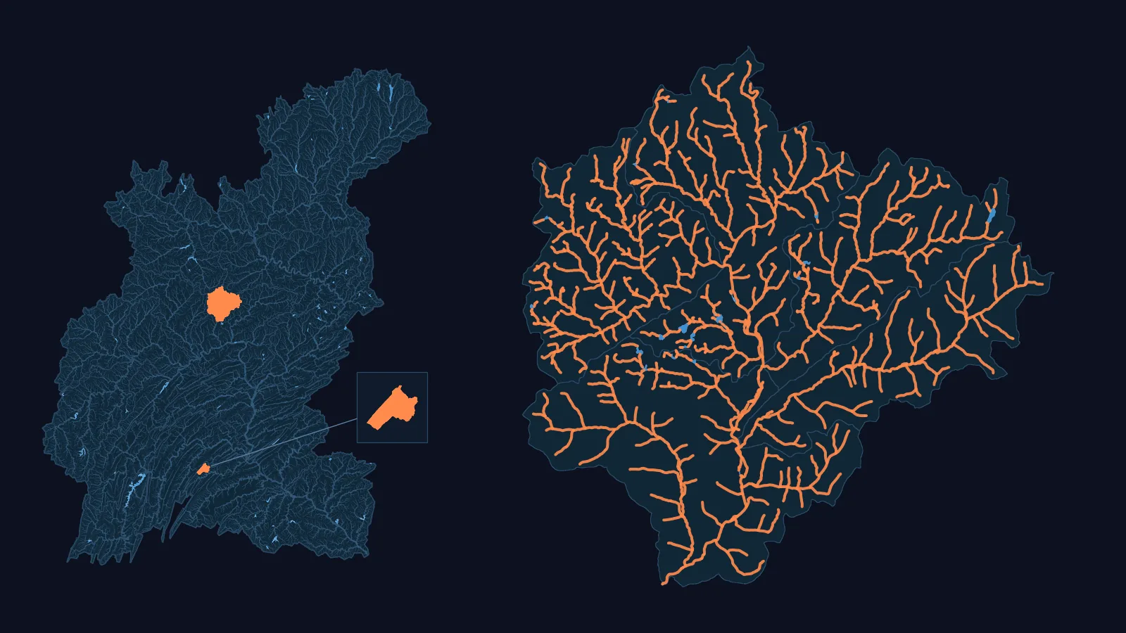
Left: the Susquehanna basin (WBD HUC4 0205) with its NHDPlus HR network, its larger lakes and reservoirs, and our two models (USGS 01550000 and USGS 01567500) in orange, the smaller one enlarged in a box. Right: the USGS 01550000 model drawn large, every one of its channels, with its water bodies in blue.
Left: the Susquehanna basin, with our two models (USGS 01550000 and USGS 01567500) in orange, the smaller one enlarged in the box, and its larger lakes and reservoirs in blue. Right: the USGS 01550000 model drawn large, its channels in orange and its water bodies in blue.
  • 2 published SWAT+ models
  • NHDPlus HR: 79,717 km of network flow paths, 1.55x NHDPlus V2.1's 51,341 km
  • 125 USGS gauges with a 90 % daily record, 2014-2024 (19 of 19 HUC8s covered)
  • 19 HUC8s both datasets carry, 71,224.1 km² (WBD HUC12 sum)

Basin: HUC4 0205 (Susquehanna) of the USGS Watershed Boundary Dataset.

Our models in this basin

Lower West Branch Susquehanna · USGS 01550000 (Lycoming Creek near Trout Run)

Lower Susquehanna-Swatara · USGS 01567500 (Bixler Run near Loysville)

Model outputs

Bixler Run near Loysville, PA (USGS 01567500), calibrated against its USGS gauge

05101520252012201320142015
Daily flow, 2012 to 2015 (m³/s): the calibrated model and the USGS gauge (grey). These are verification years: the calibration was fitted to other years.

Over these years: daily NSE 0.75, KGE 0.79, and PBIAS +2.3 % (the model simulates 2.3 % more water than the gauge measured).

From the applied calibration's verification row, key 9c23f9a2-0a29-4c55-ab40-a7d5b0ddc28e.

The same calibrated run's average annual water balance, 2012 to 2015 (mm per year, rounded to whole mm):

Precipitation1002 mm
Evapotranspiration614 mm
Surface runoff141 mm
Lateral flow65 mm
Percolation196 mm
Change in soil water-13 mm

Open the model

Lycoming Creek near Trout Run, PA (USGS 01550000), calibrated against its USGS gauge

01002003004002005200620072008200920102011201220132014201520162017
Daily flow, 2005 to 2017 (m³/s): the calibrated model and the USGS gauge (grey). These are verification years: the calibration was fitted to other years.

Over these years: daily NSE 0.63, KGE 0.71, and PBIAS -4.8 % (the model simulates 4.8 % less water than the gauge measured).

From the applied calibration's verification row, key 9956ad1d-5193-479d-b9c8-b735a940b316.

The same calibrated run's average annual water balance, 2005 to 2017 (mm per year, rounded to whole mm):

Precipitation1057 mm
Evapotranspiration468 mm
Surface runoff338 mm
Lateral flow31 mm
Percolation225 mm
Change in soil water-4 mm

Each calibration is fitted to its own gauge, on request; each chart shows one model's result.

Calibration against your gauge · Open the model

Our other models in this basin

  • Wapwallopen Creek near Wapwallopen, PA · USGS 01538000 · gauge drainage area 113.4 km² · Not offered: no channel at the gauge, so no flow chart

NHDPlus HR, not Version 2, in this basin

020,00040,00060,00080,000100,000020,00040,00060,00080,000100,000NHDPlus Version 2.1, kmNHDPlus HR, kmUpper ChesapeakePotomacLower ChesapeakeSusquehanna River BasinSusquehanna River Basin
Each point is one basin (WBD HUC4): its network flow paths in NHDPlus Version 2.1 (across) and in NHDPlus HR (up), filled with canals and ditches in both counts, hollow without them. On the line, the two would be equal. Ringed: the two datasets' areas for this basin differ by more than 5 %: Upper Chesapeake. In this figure, this basin's points are orange.

National models at this basin's gauges

At the 95 USGS benchmark gauges in this basin: NWM v2.1 median KGE 0.64, NHM median KGE 0.65. This is the national models' published skill at these gauges, not SWATGenX's. Source: Towler et al. 2023 data releases, DOI 10.5066/P9QT1KV7 (NWM v2.1) and 10.5066/P9DKA9KQ (NHM).

A model of your Bay watershed

We build a SWAT+ model for a USGS stream gauge in the Bay's four regions, on NHDPlus HR. You download it as files you open in SWAT+ Editor and run, and you keep the files.