
PFAS data availability
Where PFAS data is — and isn't — public
Ambient monitoring results are broadly available. The depth-resolved soil reports that a source term actually needs mostly are not, and that gap is measurable.
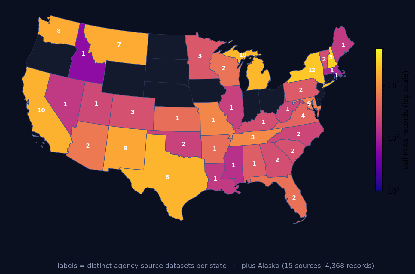
The holding today — read from the live inventories
These counts load from the public summary APIs on each visit. They drift upward as state programmes are harvested; the map and API are authoritative when a quoted total would rot.
SWATGenX also indexes PFAS litigation dockets and the underlying agency investigation reports that feed the soil and monitoring layers — the retrievability work behind the 58-of-619 site-investigation result below. Those corpora are for site context and research; they are not a map of confirmed contamination.
Watch: where PFAS data is, and isn’t
Three different things are called “PFAS data”
Most confusion about PFAS data availability comes from treating three unrelated objects as one. They differ in what they prove, and they differ enormously in how public they are.
Monitoring measurements are concentrations someone measured in water, groundwater, sediment, soil or tissue at a known location. They are evidence about the environment. Site-investigation records are the reports produced when a specific site is characterised — including the depth-resolved soil profiles that say how much PFAS is in the ground and how far down. Potential-source inventories are neither: they are lists of facilities whose industry suggests PFAS may have been used, which tell you where to look and nothing about whether anything was found.
What is public: the monitoring layer
Ambient monitoring is the healthy part of the picture. SWATGenX consolidates federal and state monitoring programs into a single inventory spanning almost every state in the country and media from drinking water and groundwater to sediment, soil and tissue. It is being actively expanded, so the station and observation totals move week to week; the live map and the API report the current holding rather than a figure quoted here that would be out of date by the time you read it.
One property of that inventory is routinely misread, and it is stable enough to state plainly even while the totals move: most PFAS observations are non-detects. Across every snapshot we have taken, the clear majority of records report that the analyte was not found above the reporting limit. That is not a defect in the dataset. A non-detect is a real measurement, and often the more useful one, because it bounds where PFAS is not — which is exactly what a transport model needs in order to be falsifiable. But an observation count quoted on its own invites a reader to hear that many detections, and that is not what it means.
What isn’t: the site-investigation record
This is the gap, and it is the one that matters for modeling. A soil concentration without its depth cannot become a source term — the whole question at a legacy site is how much material is still held up in unsaturated soil and how long it will take to arrive. Depth is the variable the model needs, and depth is the variable that most public summaries drop.
When those reports were pursued systematically (the inquiry behind our July 2026 manuscript), the result was stark. Across 619 military and AFFF installations for which at least one targeted agency repository query was made, 58 — about 9% — had a publicly retrievable depth-resolved soil report. The reports mostly exist. They are scanned PDFs in records rooms, unindexed document portals, and public-records responses; nothing links them, few are machine-readable, and depth frequently appears only inside an image of a table. The barrier is retrievability, not secrecy — which is a more tractable problem, and the reason assembling the data was worth doing at all.
The result of that effort is open and browsable as the PFAS soil inventory — depth-resolved records with full provenance (live count in the band above).
The screening layer, and what it does not mean
The platform also carries a screened potential-source layer (live count in the band above) in four categories — industrial and manufacturing, oil, gas and mining, wastewater and biosolids, and AFFF and defense. This layer marks where PFAS may have been used or released. It is not a map of confirmed contamination, and a facility appearing on it is not an allegation about that facility. It is a screening aid whose purpose is to tell you where a monitoring gap is worth worrying about — useful precisely because the monitoring network was never designed around PFAS sources.
How to get at it
All three layers are open to read. The map shows monitoring stations and potential sources together, with a preview limit on how many features an anonymous session pulls at once so the public endpoints stay responsive; an account lifts it. The soil inventory is cited by its DOI deposit, whose bulk files are embargoed through December 2026, and the same holdings are queryable programmatically through the API and the MCP server. What you do with the data afterwards — turning a measured soil profile into a source term and running it forward — is what the site-scale modeling workflow is for.
PFAS data availability: common questions
Is PFAS contamination data public in the United States?
Partly, and the part that is missing is not the part most people expect. Ambient monitoring results — PFAS measured in water, groundwater, sediment and tissue — are broadly public through federal and state programs. What is thin is the site-investigation record: the depth-resolved soil reports that say how much PFAS is in the ground and at what depth. In the inquiry behind our July 2026 manuscript, of 619 military and AFFF installations that were systematically inquired, only 58 had a publicly retrievable depth-resolved soil report. Those reports exist; they are largely not reachable.
Where can I find PFAS soil data?
There is no single federal repository for depth-resolved soil PFAS measurements, which is why SWATGenX assembled one. The v1.0 inventory holds 30,972 depth-resolved records from 5,812 borings across 39 states, Puerto Rico and the US Virgin Islands, drawn from 141 separate agency sources and covering 72 analytes, published with a DOI so it can be cited. It was built by going to individual agency repositories one at a time, because that is the only way the data can currently be obtained.
Why is so little AFFF site soil data publicly available?
Not usually because it is secret. The reports are typically produced under state or federal cleanup programs and end up as scanned PDFs in a records room, an unindexed document portal, or a response to a public-records request. Nothing links them, few are machine-readable, and depth is often reported only inside a table image. The barrier is retrievability rather than classification, which is why the systematic inquiry behind our July 2026 manuscript, across 619 sites, returned 58 usable reports.
What is the difference between a PFAS monitoring station and a potential-source site?
A monitoring station is a place where someone took a sample and measured a concentration — evidence about the environment. A potential-source site is a facility whose industry suggests PFAS may have been used or released there, such as a metal-coating plant, a wastewater treatment works, or a defense installation that used AFFF. The second is a screening layer, not evidence: it marks where to look, and a facility appearing on it does not mean contamination has been found there.
Do I need an account to use the PFAS data?
No. The map and the inventories are open to read, with a preview limit on how many features an anonymous session can pull at once so that the public endpoints stay responsive. An account lifts the preview limit. The soil inventory is cited by its DOI deposit, whose bulk files are embargoed through December 2026; browse it on SWATGenX in the meantime.
Is SWATGenX affiliated with a university or government agency?
No. SWATGenX is an independent, self-funded company. Its modified SWAT+ engine, the PFAS fate-and-transport capability, and the SWAT+/MODFLOW 6 coupling were conceived, engineered, and validated in-house, with no university or government agency funding or involvement.