Automated SWAT+ model generation for U.S. watersheds | SWATGenX
Cloud-based SWAT+ model generation: open Watershed Explorer, choose a USGS gage or HUC8/HUC12 basin, queue Create SWAT+ model, and download a ZIP for SWAT+ Editor—or mirror the same job flow with the Developer API.
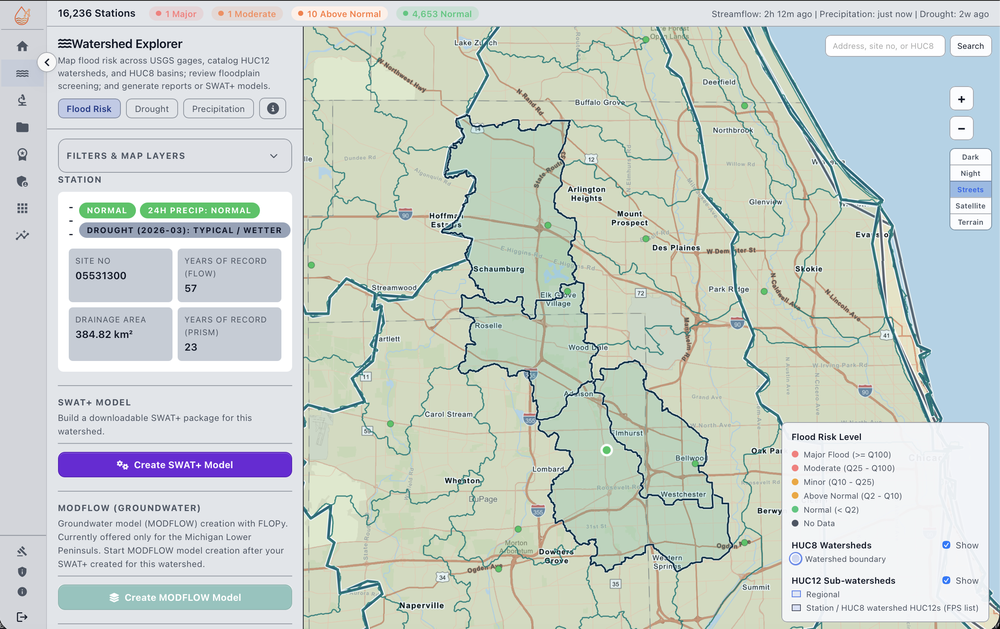
SWATGenX automates SWAT+ model generation for U.S. watersheds. Each order returns an Editor-ready ZIP—SQLite project, SWAT+ text inputs, and generated weather series—assembled from NHDPlus HR hydrography and national PRISM, NLCD, gSSURGO, and related layers. Browse example models first to see HRU counts, delineation source, and build timing before you order. You do this without desktop GIS, without QGIS, and without writing code — select a watershed and download a complete, ready-to-run SWAT+ project (the model files themselves, not just output tables).
Basin entry: USGS gage, catalog HUC12 outlet, or whole HUC8 where enabled. Watch task status in the app; optional cloud calibration is a separate Pro queue with its own estimate.
Hydrologists, students, and developers who want national prep and packaging without hand-clipping every layer.
Downloadable SWAT+ model packages — four steps
The carousel is the same Create SWAT+ model modal you use in the workspace—screenshots only, no extra account step on this page.
Developers: mirror the modal with the Developer API page (endpoints, JSON shapes, task polling, download). Public GitHub examples ship beside that doc.
Arrows or dots to change step; auto-advance pauses on hover. Click the image for full size.
Start now
Data backbone (citations & resolutions):
- 25,000+ USGS stations — live context via USGS Water Services (instantaneous values often ~15-minute; see USGS for provisional data caveats)
- NHDPlus HR — built from 1:24,000 NHD, 10 m 3DEP, and WBD; USGS cites on the order of ~27 million flowlines vs ~3 million in NHDPlus V2 (USGS NHDPlus HR)
- PRISM gridded climate (~4 km cells; PRISM defines a “day” as 24h ending 12:00 GMT); NLCD land cover 30 m; gSSURGO soils (gridded SSURGO per NRCS); NSRDB solar/meteorology nominally ~4 km (≈0.038°), 30-minute series — SWATGenX may resample/regrid for operations; see methodology for lineage
Data provenance & methodology — citations, native vs operational resolution notes, and limitations.
Automated SWAT+ model generation
- Same basin fields in the UI and on Developer API (REST + examples for auth, POST model settings, poll task status, download token).
- NHDPlus HR routing when possible; TauDEM fallback on the same rasters when HR vectors cannot complete SWAT+ channels.
- National PRISM / NSRDB / soils / land cover in the package lineage described under Methodology.
- Compare your ZIP to catalog rows on Example models before spending calibration budget.
Downloads are automated SWAT+ setups for your review and calibration—not “finished” calibrated models unless you complete that workflow separately.
Model Creation API examples (Jupyter + Python): GitHub.
Explore related
NHDPlus HR and national datasets in each package
Browse example SWAT+ models built from the same lineage; open the Watershed Explorer to pick a basin; read why SWATGenX uses NHDPlus HR automation; or compare watershed modeling software for U.S. SWAT+ workflows.
HUC8 and HUC12 watershed entry points
Every SWAT+ order starts by defining a drainage basin. In SWATGenX, the drainage basin is represented as a set of one or more WBD HUC12 polygons. Catchments from NHDPlus HR inside that basin are then used to build the landscape units (HRUs) and connect them to the routed stream network.
| Entry point | What you choose | How SWATGenX turns that into a basin |
|---|---|---|
| USGS station (gage) | A USGS site number | SWATGenX looks up the station in the platform’s station table and uses its precomputed list of upstream HUC12s as the drainage basin for that gage’s outlet. |
| Catalog outlet (HUC12) | An outlet HUC12 in Watershed Explorer | SWATGenX performs an upstream walk from the selected outlet HUC12 to gather the full set of upstream HUC12 polygons that drain to that outlet (with safety limits on very large watersheds). |
| Whole basin (HUC8) | An entire HUC8 subbasin | SWATGenX derives the basin as the set of HUC12s that fall within that HUC8 and then assembles the full SWAT+ package for the whole subbasin footprint. |
Key idea: HUC12s define the study-area drainage basin. Catchments inside that basin (finer than HUC12) are used to clip terrain, soils, and land cover and to create SWAT+ hydrologic response units (HRUs) that align with NHDPlus HR routing.
National context for the current prepared dataset: 87,387 HUC12 catalog polygons, 2,246 HUC8 subbasins, 24,750,692 NHDPlus HR flowlines, and 24,833,258 catchments (~24.8M) across 233 VPUIDs in CONUS.