SWAT+ watershed simulation platform for the U.S. | SWATGenX
National hydrography, live USGS context, automated reporting, and SWAT+ (SWAT Plus) simulation workspaces — without desktop prep.
SWATGenX is a watershed simulation platform for scenario analysis, what-if modeling, and hydrologic forecasting across U.S. watersheds — connecting continental datasets to both rapid screening and full SWAT+ simulation projects.
Evaluate basins with live USGS streamflow context, map-based exploration, automated reporting, and optional SWAT+ simulation packages tuned to NHDPlus HR detail.
Users who need simulation-grade outputs but want a hosted workflow spanning screening and detailed SWAT+ runs.
Not a substitute for site-specific hydraulic certification or all groundwater/surface coupling problems. SWATGenX links screening to SWAT+ continuous simulation for watershed-scale planning—not every hydrologic use case.
Explore a real aquifer in 3D — live
This is a real SWATGenX model running on this page: a six-layer MODFLOW 6 aquifer beneath a Michigan headwater catchment, built automatically from state well records. Drag to orbit, peel the layers, slice top-down, and hover any cell for its hydraulic conductivity.
Conceptual watershed
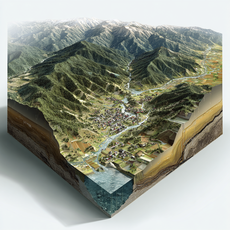
Illustrative basin — surface hydrology, land use, and subsurface context aligned with process-based simulation (e.g. SWAT+) at watershed scale.
Start now
Data backbone (citations & resolutions):
- 25,000+ USGS stations — live context via USGS Water Services (instantaneous values often ~15-minute; see USGS for provisional data caveats)
- NHDPlus HR — built from 1:24,000 NHD, 10 m 3DEP, and WBD; USGS cites on the order of ~27 million flowlines vs ~3 million in NHDPlus V2 (USGS NHDPlus HR)
- PRISM gridded climate (~4 km cells; PRISM defines a “day” as 24h ending 12:00 GMT); NLCD land cover 30 m; gSSURGO soils (gridded SSURGO per NRCS); NSRDB solar/meteorology nominally ~4 km (≈0.038°), 30-minute series — SWATGenX may resample/regrid for operations; see methodology for lineage
Data provenance & methodology — citations, native vs operational resolution notes, and limitations.
Simulation plus screening on one platform
Many tools split “quick maps” and “serious models.” SWATGenX links them: the same national fabric supports flood context and downloadable SWAT+ simulation workspaces.
Screening vs SWAT+ simulation
Screening answers portfolio questions with live USGS context, return-period classification (Bulletin 17C–aligned LP3 on annual peaks), and PRISM percentile rainfall classes. When you need multi-year process responses or defensible SWAT+ scenarios, download a project package and continue locally.
EPA describes SWAT as simulating water quantity and quality effects of land management and climate; SWAT+ extends that role with a restructured, relational model design.
What you can do with SWATGenX
- Scenario analysis in the SWAT sense: land management, climate series, and multi-year continuous responses
- Screening → simulation ladder: stay in map metrics until you need process-based SWAT+ time series and downloadable projects
- Constituent and sediment questions tie to soils, land cover, and climate inputs already on the platform
- Water-quality angle: dedicated water-quality modeling software page (nutrients, sediment, BMP scenarios)
Model Creation API examples (Jupyter + Python): GitHub.