Cloud-based watershed modeling workflow
CONUS watershed modeling platform for SWAT+ generation
Pick a basin in the map, export a PDF, queue a SWAT+ ZIP—one national workflow from screening to delivery.
NHDPlus HR hydrography plus PRISM, NLCD, gSSURGO, and related national layers—same lineage in Explorer, reports, example models, and generated packages.
- Map screening & selection
- National datasets
- Reports & downloadable outputs
- SWAT+ / QSWAT+ ready
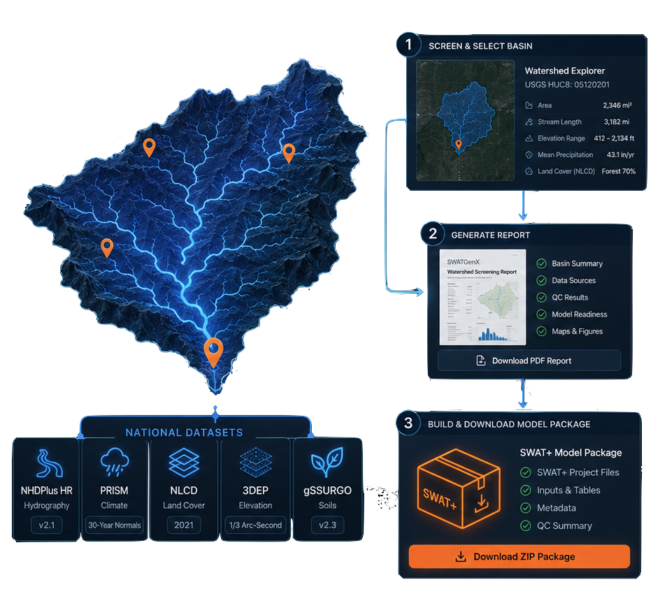
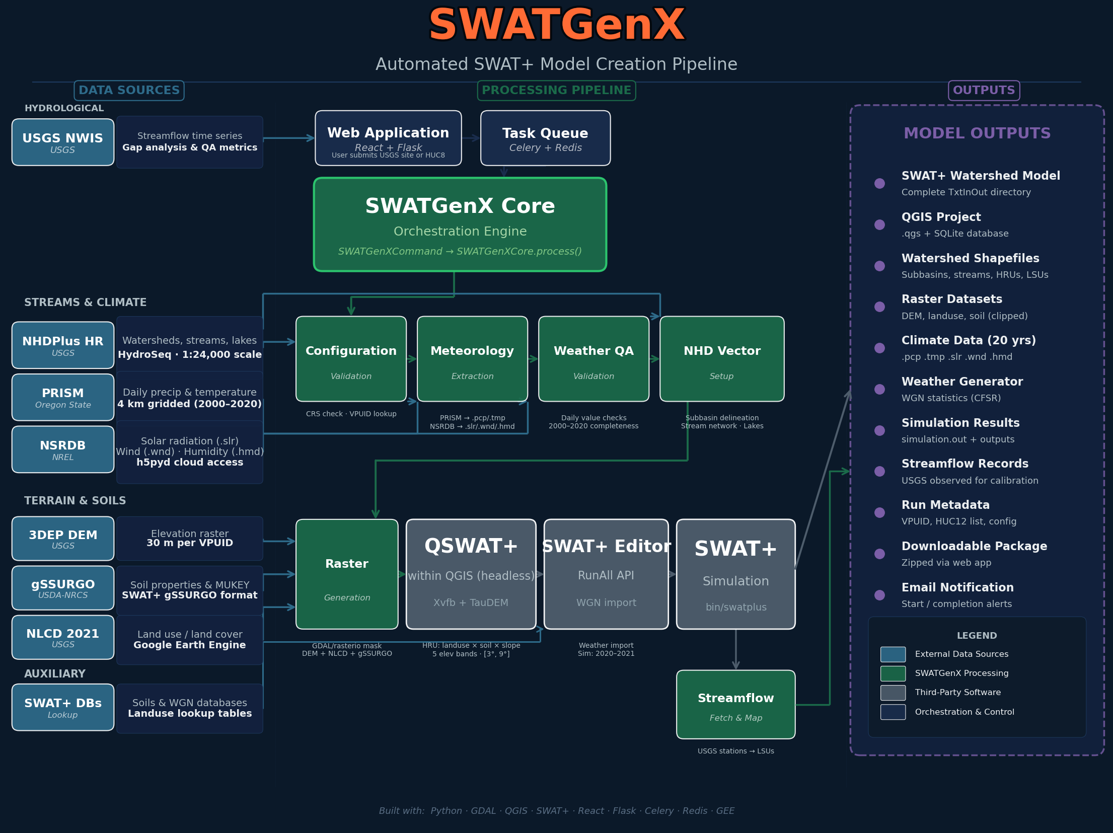
SWATGenX is a web-based CONUS watershed modeling platform for automated SWAT+ model generation: screen HUC8 and HUC12 basins in Watershed Explorer, read context from NHDPlus HR hydrography and national soils and climate layers, export watershed PDFs, and queue downloadable SWAT+ packages—without rebuilding national clips in desktop GIS. The same services power the UI and the Developer API.
Create a free account to open Explorer immediately. Shortlist basins with map metrics and PDFs, then inspect lineage in the public example-models catalog. When you need your own package, sign in, confirm plan limits on Pricing, and submit a model order—track status in the app or poll the same REST endpoints you can drive from Python with an API key.
Consulting program managers, utility planners, state analysts, integration engineers, and research labs that want one hosted stack instead of ad hoc desktop silos—plus anyone evaluating SWATGenX on the free tier before upgrading.
One lineage from map screening to downloadable SWAT+
The same national hydrography, soils, land cover, and climate fabric backs streamflow and rainfall context in the map, tables in PDF reports, rows in the public example-models catalog, and the contents of generated SWAT+ ZIP files.
Core REST entry points mirror the UI: POST /api/model-settings (USGS gage), POST /api/model-settings/explorer-watershed (outlet HUC12), POST /api/model-settings-huc8 (whole HUC8), GET /api/model-orders, GET /api/task_status/<task_id>, GET /download_model/<token> — see Developer API for JSON fields and Python snippets.
Explore a real aquifer in 3D — live
This is a real SWATGenX model running on this page: a six-layer MODFLOW 6 aquifer beneath a Michigan headwater catchment, built automatically from state well records. Drag to orbit, peel the layers, slice top-down, and hover any cell for its hydraulic conductivity.
Next steps
Data backbone (citations & resolutions):
- 25,000+ USGS stations — live context via USGS Water Services (instantaneous values often ~15-minute; see USGS for provisional data caveats)
- NHDPlus HR — built from 1:24,000 NHD, 10 m 3DEP, and WBD; USGS cites on the order of ~27 million flowlines vs ~3 million in NHDPlus V2 (USGS NHDPlus HR)
- PRISM gridded climate (~4 km cells; PRISM defines a “day” as 24h ending 12:00 GMT); NLCD land cover 30 m; gSSURGO soils (gridded SSURGO per NRCS); NSRDB solar/meteorology nominally ~4 km (≈0.038°), 30-minute series — SWATGenX may resample/regrid for operations; see methodology for lineage
Data provenance & methodology — citations, native vs operational resolution notes, and limitations.
After you submit an order
Delineation and QSWAT+ / SWAT+ Editor assembly run as hosted asynchronous jobs with status you can follow in the app or via the API. Map screening stays lightweight in the browser. Queue time and feature gates vary by plan—use Example models and Pricing to set expectations before you scale a portfolio.
Cloud-based watershed modeling workflow
- Open Watershed Explorer on a free account: CONUS map screening, live USGS context, HUC8/HUC12 navigation, screening layers, and watershed PDF exports for your short list.
- Browse Example models: filter by basin, inspect HRU counts and delineation lineage, download published SWAT+ ZIPs before you order your own.
- Sign in to queue SWAT+ builds when you are ready: asynchronous jobs, in-app status, and a secure download when the package is ready (plan limits on Pricing).
- Automate batches from Python: REST endpoints mirror the UI—see Developer API for request bodies, task polling, and public Jupyter examples.
SWATGenX is a hosted workflow platform for screening, model setup, and delivery. Platform features, queue times, and access limits are operational controls and should not be interpreted as guarantees of study readiness, regulatory acceptance, or final model performance. Agency and data-steward names on the methodology hub are for attribution only — no endorsement by USGS, USDA, NOAA, or other cited providers is implied.
Model Creation API examples (Jupyter + Python): GitHub.