Watershed Modeling Software for the United States
Watershed modeling software that screens flood risk, analyzes hydrology, and generates SWAT+ models — across 16,000+ USGS stations and every HUC8 basin in the Continental United States (CONUS).
SWATGenX is a watershed modeling software platform for flood risk analysis, hydrologic modeling, and SWAT+ model generation across the United States. It combines national datasets, automated workflows, and the SWAT+ engine in one browser-based environment.
As watershed modeling software, SWATGenX screens flood risk, analyzes hydrology, and generates reports in minutes across 16,000+ USGS stations and every HUC8 basin in the Continental United States (CONUS).
Need hydrologic models for CONUS watersheds? SWATGenX automates SWAT+model preparation, calibration, and validation in an elastic cloud computing environment. Create watershed models for any basin in the United States — no GIS setup, no hydrological modeling experience, no manual data prep.
Built for environmental engineers, water resource consultants, and watershed planners — hydrologic modeling software designed for rapid watershed analysis, flood risk modeling, and water quality simulation across the US.
In one sentence: SWATGenX is a U.S. watershed stack that combines continental screening (live USGS context, return-period classification, PRISM percentile rainfall, PDFs) with optional SWAT+ model packages on NHDPlus HR — one workflow, not three tools.
Backbone (authoritative sources): USGS documents NHDPlus HR’s large increase in reach count versus NHDPlus V2; PRISM is the Oregon State gridded climate product; WBD defines official HUCs. Citations, native vs operational resolution notes, and limitations: Data & methodology. Definitions and taxonomy: Watershed modeling guide. Comparisons: Watershed modeling software.
Who it is not designed for: If you need FEMA-certified hydraulic floodplain mapping or detailed structure hydraulics, plan on HEC-RAS–class studies — SWATGenX is triage and SWAT+ hydrology, not a substitute for those deliverables. See SWAT+ vs HEC-HMS and flood methodology.
Access & usage
Two tiers, each tied to concrete deliverables:
Free
- CONUS map with real-time flood risk classification
- Station and basin exploration with streamflow & rainfall context
- PDF watershed reports (flood risk, floodplain zones, population, cropland)
- Floodplain and population exposure analysis
- Generate and download SWAT+ models for HUC8/HUC12 scales
Pro
- Calibrated SWAT+ model with 20 years of simulation results
- Water balance outputs (runoff, recharge, ET, soil moisture, etc.)
- Water quality outputs (nitrogen, phosphorus, sediment, etc.)
- Agricultural outputs (crop yield, irrigation demand, etc.)
What you can do today
- Flood risk screening — identify flood-prone watersheds using real-time streamflow vs. return-period thresholds
- Streamflow & precipitation monitoring — live USGS flows and 24-hour NOAA MRMS rainfall in historical context
- Watershed reports — floodplain mapping, population exposure, cropland analysis, downloadable PDFs
- Scenario comparison — compare basins side-by-side for planning and prioritization
How organizations use SWATGenX
- Rapid watershed screening — assess any U.S. watershed in minutes instead of weeks of manual GIS work
- Flood risk pre-assessment — classify stations and basins before committing field resources
- Automated reporting — generate client-ready PDFs combining hydrology, floodplain, population, and land-use layers
- Scenario analysis for planning — compare watersheds and conditions to support infrastructure and land-use decisions
Watershed Explorer
The Watershed Explorer is the single entry point: select a USGS gage or HUC8 basin, view real-time flood risk, run analyses, and download reports.
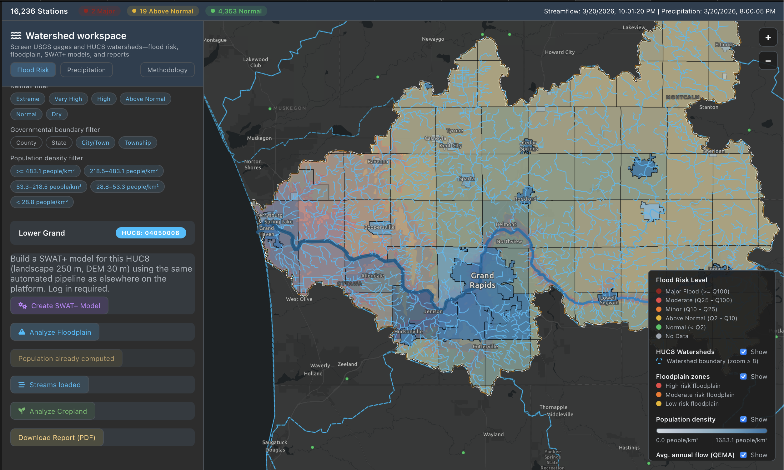
Click the image for a full-size view.
Decision-ready watershed reports
SWATGenX generates comprehensive, multi-layer PDF reports for any USGS station or HUC8 watershed — combining flood risk, floodplain mapping, population exposure, cropland analysis, stream network context, and water-use data into a single document. Reports are produced on demand, fully automated, and delivered to your email.
What every report includes:
All data is sourced from national public datasets. No proprietary data, no manual preparation.
Get started
Pick a station or basin on the map. Create a SWAT+ model for your desired HUC8 watershed, run flood screening, generate a report, or explore watershed layers — all from one place.
Proven at scale
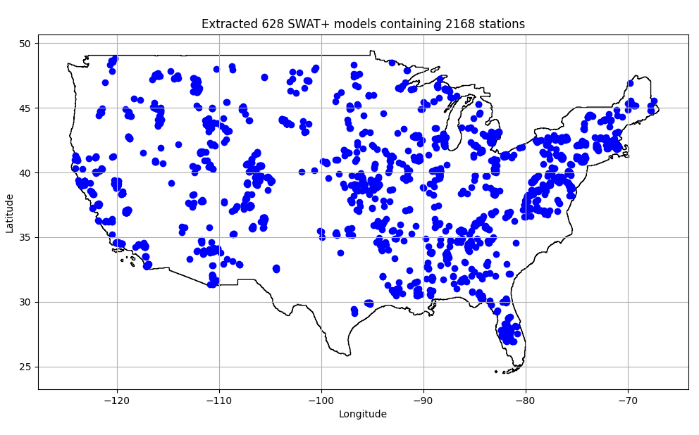
Used to analyze hundreds of watersheds across the U.S. — including 628 unique hydrologic models at varied spatial scales.
Advanced modeling & simulation
When screening and reports aren't enough, SWATGenX generates calibrated SWAT+ watershed models — the same engine used in peer-reviewed hydrology research, fully automated.
SWATGenX is not an alternative to QSWAT+. It automates and scales QSWAT+ + SWAT+ Editor setup for faster watershed model delivery.
- Water balance — surface runoff, groundwater recharge, evapotranspiration, soil moisture
- Water quality — nitrogen, phosphorus, and sediment transport
- Agricultural production — crop yield and irrigation demand under different scenarios
- Long-term simulation — 20+ years of daily outputs for trend analysis and planning
- Downloadable model packages — complete SWAT+ projects ready for local execution or further calibration
Technology
Screening, mapping, and reports run on national public datasets — no proprietary data required.
- USGS NWIS — real-time and historical streamflow (16,000+ stations)
- PRISM — gridded precipitation and temperature (4 km, 2000-present)
- NREL NSRDB — satellite-derived solar and meteorology; see NREL for native grid spacing (SWATGenX uses daily drivers resampled for SWAT+ weather files)
- NHDPlus HR — stream network and elevation (1/3 arc-second DEM)
- NLCD / gSSURGO — land cover and soil properties
Architecture
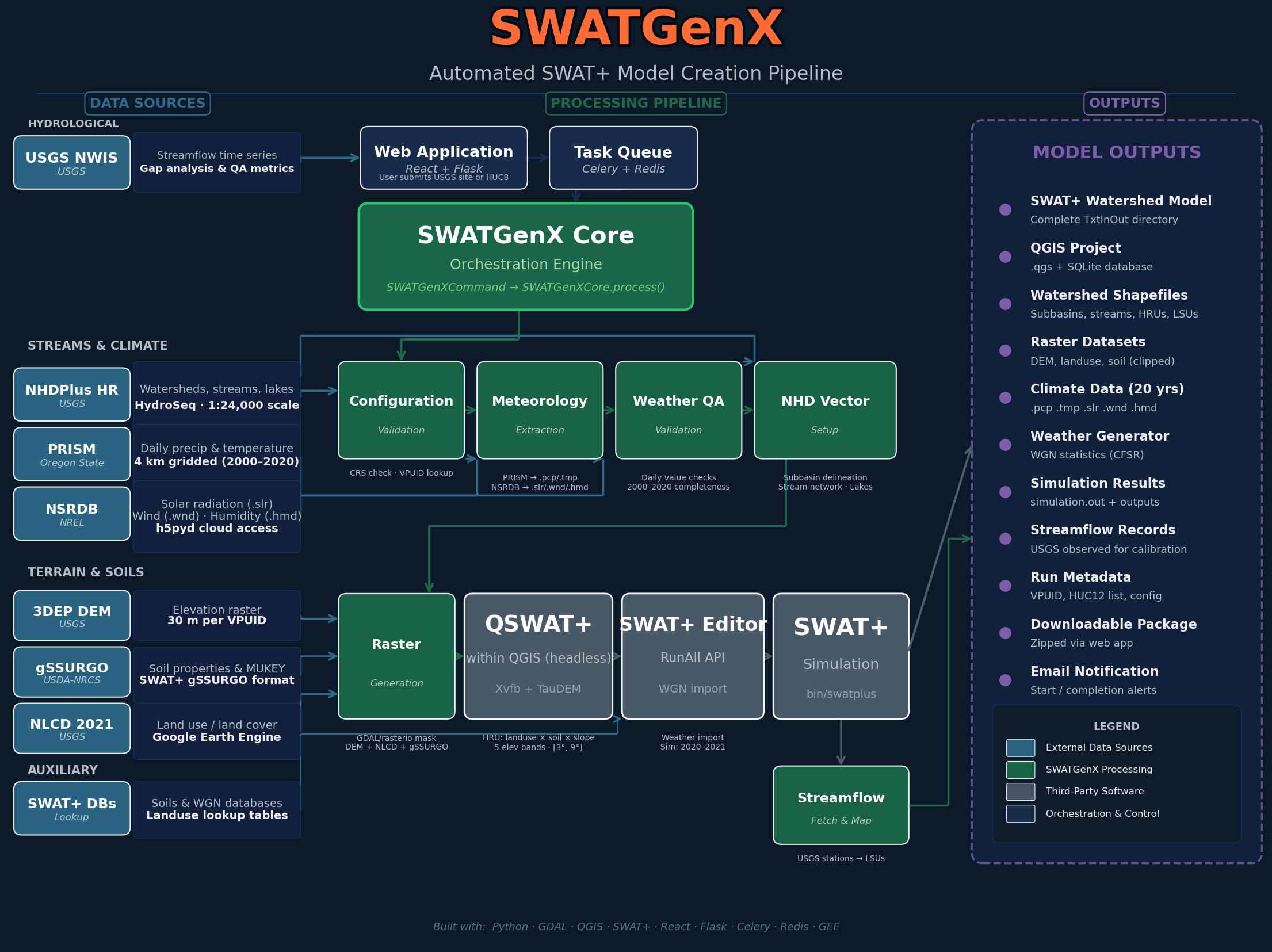
From national datasets to analysis, reports, and optional model builds — fully automated
Appropriate use
Flood and rainfall indicators on SWATGenX are for rapid triage and planning context, not a substitute for site-specific hydraulic studies, FEMA flood insurance studies, or official emergency warnings. For methodology and citations see Data & methodology.